Day 2 of My 60km Coastal Hike Adventure

On the second day of my 60km journey, I woke up again very early, sometime around 615am. I slept like a brick that night and it was nearly a full moon so I had plenty of light to help me pack up camp. After I packed up, I made coffee and set off. The thing I learned very early on this day, was I CANNOT hike with coffee. I am sure many people reading this are going “duhh!” but after years of front-country experience, where I start every morning with food and coffee, usually out of the cooler, it was a new experience having no interest in coffee in liquid form because every sip just made me thirstier than the last. After about 3km I actually dumped it out so I wouldn’t be tempted anymore and switched to water and bio steel for the rest of the day.  

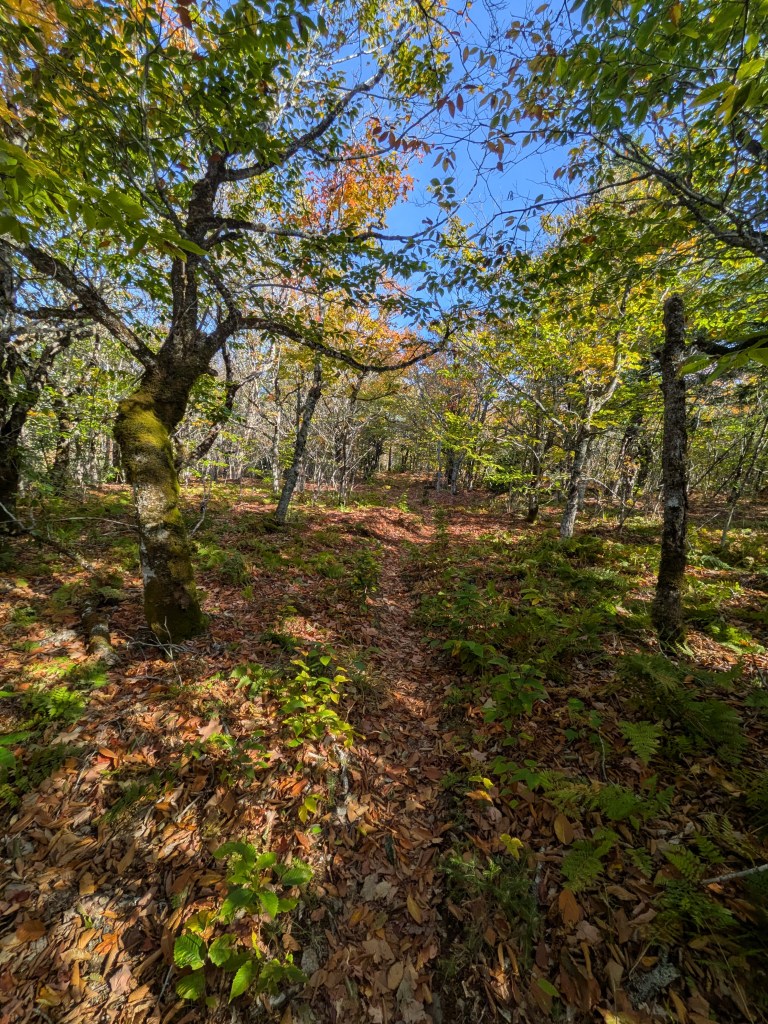
Heading off today the plan was to continue to hike north towards the Eatonville and day use trails, and see a sea stack called the Three Sisters. I took the “backcountry trail” there, and it was very tight, probably not seeing near as much maintenance as the main Coastal trail that I was following, so it was rough going but ended up connecting to the day use trails directly without going to the secondary visitor center. I learned a lot about Eatonville, its shipbuilding history and its sea stacks in general. This part of the park was closed for the season already, but I was assured when I checked in that all that meant was that there was no parking at the north end of the park, so I had the whole area to myself.
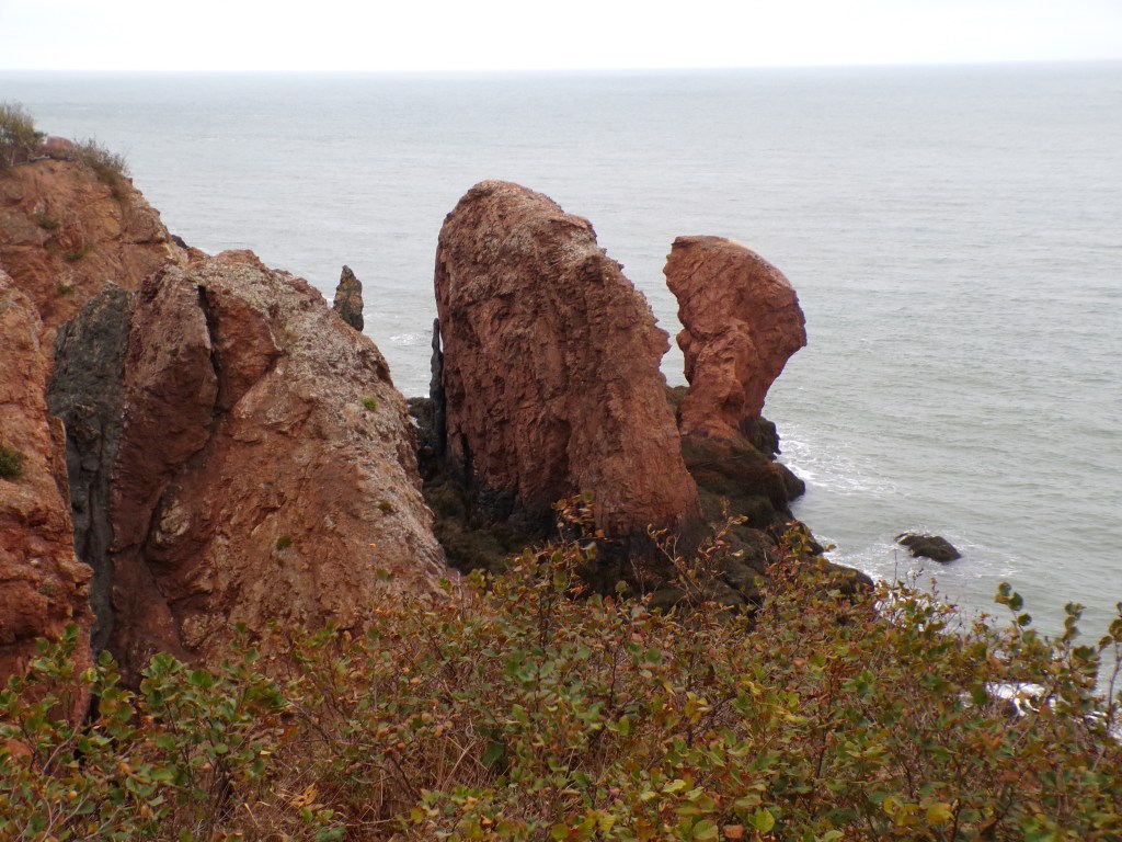
KODAK Digital Still Camera

The Three Sisters

 I am an eternal skeptic when it comes to rock formations that claim to have faces in them, I can’t see anything other than rocks usually! But this was different, my pictures don’t do it justice but I actually saw the faces and there are a couple of interpretive signs that talk about the story of the formations and the legend surrounding them. The day use trails to access the viewpoints are well maintained and very flat, a welcome break and good way to ease into the total distance I was traveling today which ended up being around 24km.

The Coastal Trail

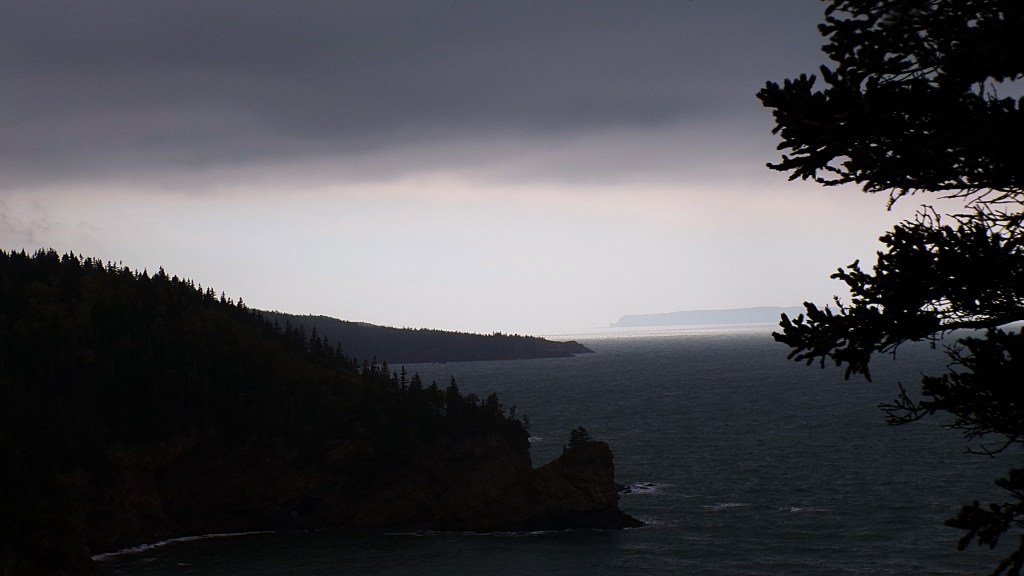
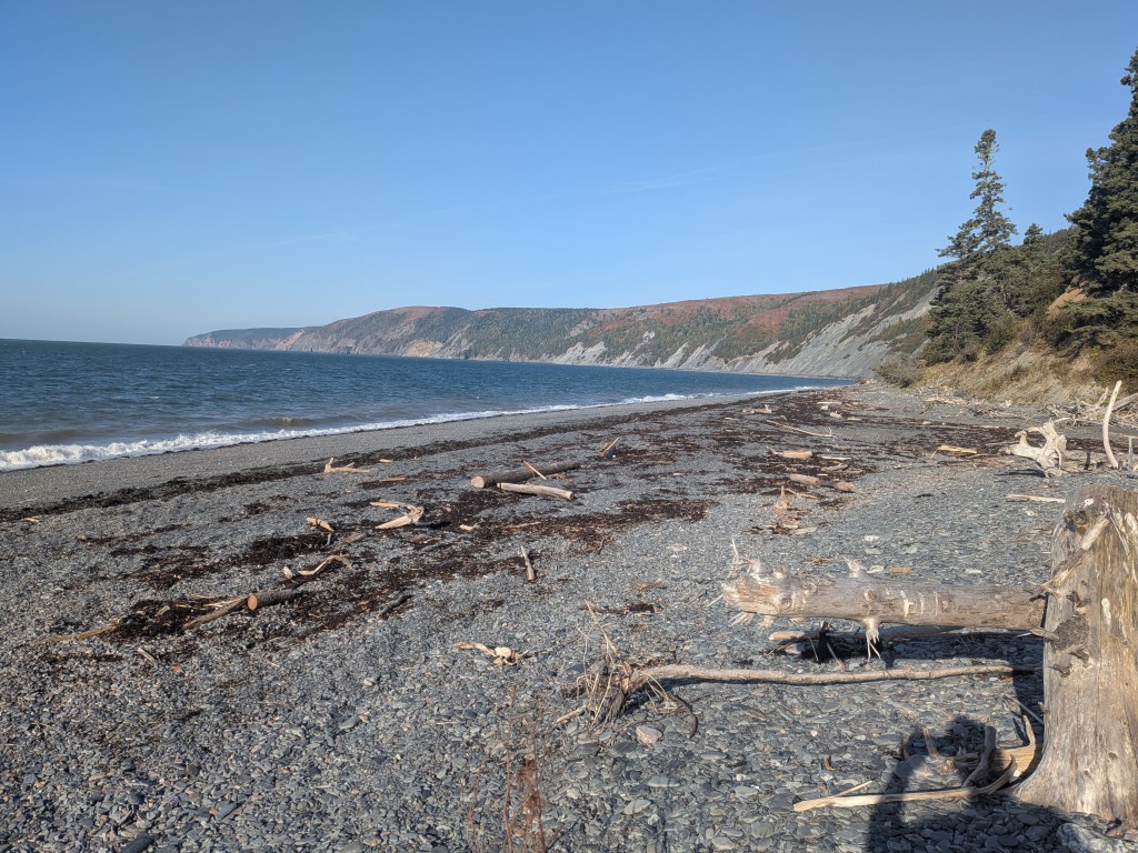
Once I got done with my rather touristy side quest, I was back on the main trail and now headed towards the coastal section. This was the part of the trip that I was most looking forward to, this is where I had made a plan to take the day a little slower and take tons of photos, really enjoy the day. The day from a weather standpoint wasn’t great, I knew that storm was coming in within the next day or two, and that produced drizzly and overcast conditions for most of the morning. Sadly, as a I progressed the phots all started to look alike, and then came the elevation change. For those that haven’t been, the Fundy coastline is very rocky and marked by cliffs and many streams, a lot of it was formed by receding glaciers, so imagine a ball of sand, that someone had taken a chuck out by squeezing their fingernails together, and then filled the chunk with water,  the real world effect is simply seen while you hike, whenever you come to a stream, you drop about 70-110m and then you climb back up, often within 1 or 2 km. This was tough, definitely the hardest part of the hike to this point, by noon my knees were starting to really feel it. Luckily the weather started to get better so I was able to ignore my aches and pains and have a really nice time. Walking along the coast, the thing that struck me compared to the previous day was the noise. Not just the wind whipping me in the face, but the waves hitting the rocks, it was like hearing a three-car collision every couple of minutes, I wondered if I would be able to sleep tonight as I went along, knowing that my campsite was just up from a rocky beach. In the afternoon the sun came out, the wind stayed strong but it warmed up a little and I was able to shed a layer and have a very enjoyable time just hiking along, lost in my own thoughts.

KODAK Digital Still Camera

 Little Bald Rock

I am camping a Little bald rock tonight, the last water station is set up at Big bald rock, which is where I took one of my last breaks on the day. The two sites are about 4km away from each other. So, as I’m sat at a picnic table, these are the thoughts running through my head:

  1. Should I stay here tonight rather than carry on?
  2. If I do that, will I be able to make it to the visitor center tomorrow before the rainstorm rolls in?
  3. Do I have the energy left to carry enough water to the campsite to last the night and the morning before I can make it to the next water station?

So, I started to think and answer the questions in my mind. I didn’t want to stay there because it wasn’t part of the plan, which in the real world is a ridiculous thought, but the weather was favorable and it was still early, around 4pm, sun was setting just after 6pm or so, so there was time to make it, even at a slow pace. I also believed that the extra 4km added to tomorrow would delay me to beating the storm, so I would have to push on. Answering the last question was tough, especially because at that moment I was completely gassed. I figured I had just enough energy to set up camp and fall asleep, but in the end, I decided to push myself and get through. In order to make sure I had enough water, I filled all my reserves, and then filled my kettle, which I could not strap back to my pack lest the water fall out on the way, and with my bag done up and my kettle in ne hand and Yeti in the other, started walking to my campsite. I got about ten steps forward and nearly fell down the hill because I was very unbalanced now and unable to brace myself with my hands full, but there was no going back now so I had to push on. After about a kilometer and a half my mind and body were screaming to turn back, instead, I started to count steps. I know that one of my strides is about half a meter, so I needed to count to two thousand and that would be one km. I started doing this with about 2km to go, but counting steps was incredibly boring, so to keep my mind occupied, I pretended that I was climbing the stairs of a mountain top temple in some far-flung corner of the world to make tea for whoever was at the top. Incredibly the little mental trick along with counting steps worked, and I made it to my campsite in just over an hour and with my second wind was able to get my camp setup and dinner made and then sit and relax and most importantly, stretch after an extremely long day. By now the weather had turned back to dreary and no sooner had I entered my tent than I was asleep. I only woke up once in the night, the waves hitting the beach were actually quite pleasant, a departure from the morning wave sounds, but the book I had brought to read in downtime, would go again unread.

KODAK Digital Still Camera

Cape Chignecto: A Fall Adventure in Nova Scotia’s Wilderness

Cape Chignecto Provincial Park in Nova Scotia offers stunning coastal scenery and a challenging hiking experience. The author shares their solo journey in October, contending with steep ascents, unpredictable weather, and water supply challenges due to a drought. Despite difficulties, the experience fosters appreciation for nature and proper preparation.

Cape Chignecto is a provincial park in West Advocate, Nova Scotia, about three hours’ drive from Halifax airport and a three-and-a-half-hour drive from my home in Annapolis Royal, Nova Scotia.

The journey to and from is lovely in and of itself, pastoral farmland is quickly replaced by rugged coastline and the bay of Fundy with its dramatic tidal basins make the ocean look endless with the tide in or as if it is a giant beach when the tide is out. I went during the first week of October, when the entire province seems to be a riot of fall colour and foliage. this also presents some challenges with the weather being generally unpredictable in the fall. Luckily, the weather was great, except for the torrential rain I got caught in on the last day.

My start from the visitor centre was great, the check in process very easy and many of the warnings that are visible on the website are repeated by the staff with great care. This past year in NS, there was a historic drought, so the park had set up water stations and marked them on the updated map. One thing that is important to note, is that even though this is a provincial park and a relatively closed loop and everything is well marked, this is still a “wilderness zone” as such, it is important to bring a compass or GPS system, and some emergency items in case you get lost. One of these items should be a map. If you are like me, you probably hate that at every turn in the Hiking industry there is someone telling you to spend more money for everything, including but not limited to adequate mapping. I am here to tell you spend do not need to spend a tin of money on maps, depending where you are going. In this case, you can download topo maps, and trail maps from the website, in a handy PDF format. Once I had them all downloaded, I printed and laminated them at the library, so all my maps for this trip cost about three dollars. The laminating was a great call, this ensured they would stay dry if I dropped them in the water, or got rained on. This experience ensured I will never take the library for granted again.

My pack weight was 45lbs. not too heavy but not exactly light. Also, do remember dear reader, I am alone, no one to help carry the weight, so keep that in mind when we start ascending 500m up the Fundy cliffs.

Once I had set off from the visitor centre, I was able to walk the first kilometer on the beach, something that is only possible at low tide, this is the only part of the journey that requires tide time knowledge, which seems deceptive considering it’s a coastal trail. But after the rocky beach walk, that when the real fun began. The first 5km, like the entire first day, is uphill and very steep. To say I was unprepared for what lay ahead would only be a small understatement, it was how steep the climb was that took me aback, as it does not look this steep on a topo map.

And yet at the first view spot I was completely out of breath. This is when it was great to be alone, so no one could see me sweat. I made the decision to pull out my neck gator and take my sweater off, and that kept the sweat off my neck as the daytime temp never went above 10C and I didn’t want to catch a cold.

Sadly, the last good view on the day was at KM marker 4 as the path diverges into the forest, the path also leveled out quite a bit and then I was able to catch my breath and start making some progress on the day. A quick lesson I leaned that morning, progress only feels good when you return to your normal speed. I literally at times and figuratively crawled to this point and believed that I would never make it to the end, but of course, I did. As I hiked off into the woods, I felt great, and focused on the birds, the trees and my own breath.

The last 15km of the first day were by comparison, noneventful. The trail was a little awkwardly marked as I approached a marshy area as I came close to the Eatonville bunk house, but AllTrails helped me navigate that bit. Unfortunately, the only water on the map was at the Eatonville bunk house, and as I passed it, I decided not to stop for water, preferring to find my campsite for the night and have a nap. I got to the campsite at around 2pm, at a giant field that could have slept 100 people, but it was only me. In hindsight, I should have stayed at site #7, hidden away from the field, by a little brook which had very little strength given the drought that had been going on and was not a good water source. Which meant hat I had to hike 2km each way to fill up my water, so I set up my camp, repacked my bag and headed off for the cabin. It was closed for the season, but for anyone not interested in sleeping outside, they look nice, and sleep about 8 people.

All in all, it was a long day, the hottest of the three, and the least interesting from a lookout perspective. I got to sleep around 930pm, ready to wake up at 6am to start the next day which proved the most arduous.

Your Guide to Hiking Cape Chignecto: Maps & Accommodations

When we last left off, I had determined that I would need three days to hike the Coastal loop, but would budget four just in case. So now I’ve started to consider the route. First things first, I need a map.

https://parks.novascotia.ca/park/cape-chignecto

If you go on the Parks Nova Scotia website and click on Cape Chignecto, you will find a wealth of information such as, entrance fees, booking availability and camping fees. Also, you can download a map of the park. The map contains a trail map, detailed maps of the various campgrounds and a topographic map of the park and surrounding area, all for FREE. Since I plan on going myself, I will be printing the downloaded map and getting it laminated at Staples, that way I can bring it with and it can stay weather resistant.

I have AllTrails plus, so I can also print out supplementary maps with satellite photos of the terrain and weather. I’ll use those print outs to mark out my path since I’ll be leaving my travel plan with my wife and dog.

Currently, in order to maximize my time, I am leaning towards hiking the trail in a counter clockwise direction, meaning from the entrance I’ll be headed north towards Eatonville and that campground rather than west towards Mill Brook. This means that distance traveled on day one will be about 12-15km.

The reason for this is that the starting route is mostly wooded forest area, not much for dramatic ocean views or particularly great pictures.

I personally don’t thing that it matters which way I decide to take the trail, since it’s a short trip, my pack weight will remain relatively consistent since the only thing I’ll be losing is a few grams every day in dried food, so I’d like to be in the home stretch at the ocean where I can take photos and perhaps stop more to take in the view.

Another advantage to going this way is that there are more campgrounds on the west side of the park, if the weather turns nasty there will be more opportunity to find shelter and refill my water canteen.

For the next day I will have to make a decision at booking time, whether to go from Eatonville to Little Bald rock (LBR), or to push on Refugee cove (RC). LBL looks to be about 8-10km from Eatonville with RC being another 4km past that. At LBR there are only 4 campsites whereas RC has 11, so it will be a booking day decision to see which fills up faster or if I’d rather be in a less populated space for the night, which is usually my preference.

This also changes the last hiking day from either a 3ish km journey to almost 8km journey. Either of these are doable considering I’ll only have emergency food provisions and enough water for the day, so not much to slow me down with weight in the bag.

Of course, these are all relative distances based on an estimation looking at the park map, when I print it out ill be able to make more detailed predictions about distances and travel times, and I’ll be able to supplement those estimations with trail reviews and AllTrails data.

The last question that I want to think about today is where my wife and dog will sleep, I may have mentioned before that they DO NOT want to come with, Toto would but my wife wants him to keep her company. So, I’m looking at Pet Friendly accommodations near the park entrance in West Advocate.

Home – Fox Point Inn

Fox Point Inn looks like a perfect place to keep my family, its pet friendly and only about 20 min away from the entrance, it’s also under $200 a night. The rooms look comfy and they look like they come with all the modern amenities, if I wasn’t headed out backpacking this would be a great place for us all to stay as its near Cape Chignecto, Five Islands and Cape D’or, all with hiking trails to explore. Its 20 min to Parrsboro, so close enough if Britt needs to run out for anything.

Next time I’ll start to focus on the gear I’ll need for the few days and creating a pack list, as well as figuring out booking day. See you then!